
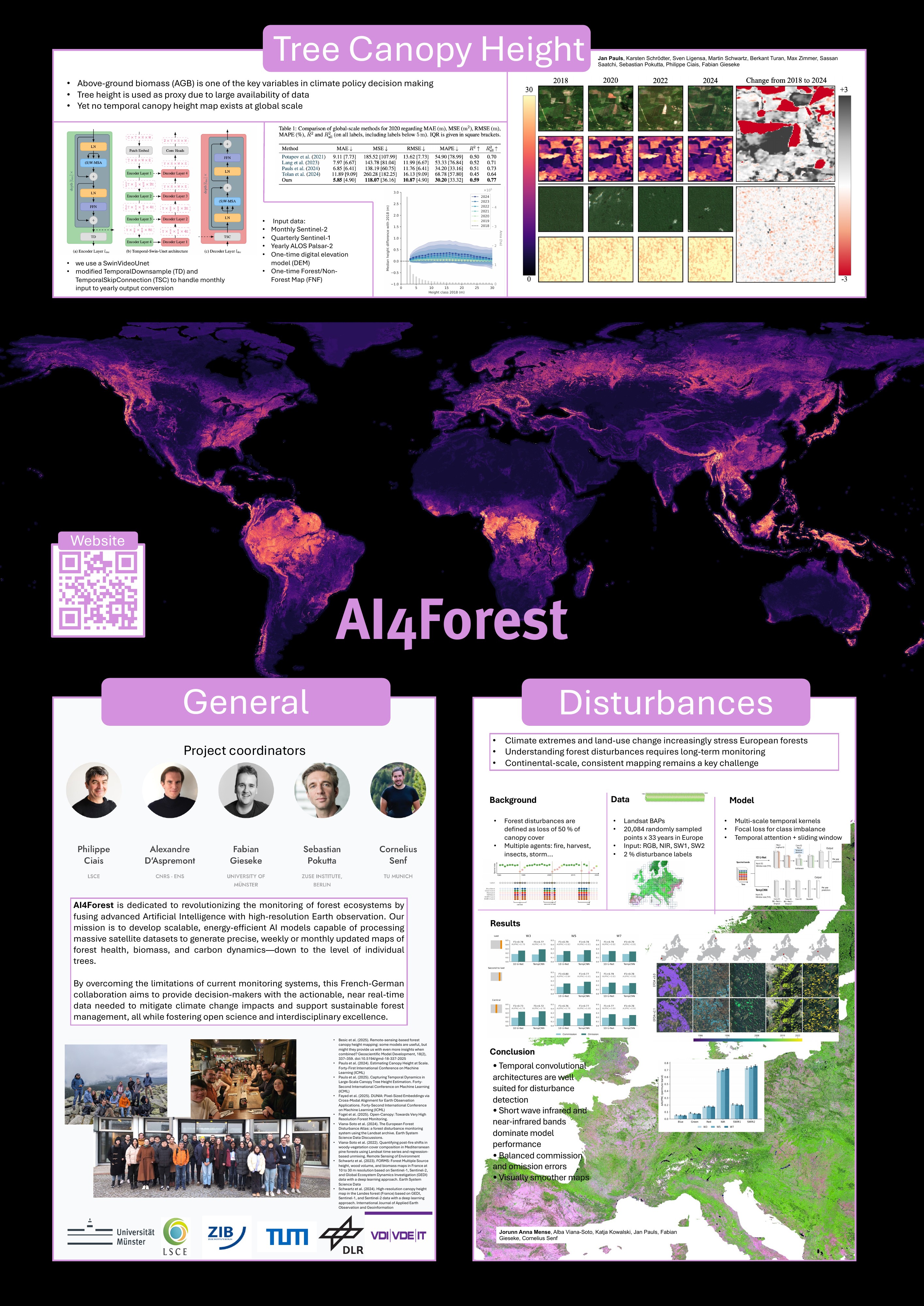
Research from the AI4Forest collaboration.

Scientific Output

Peer-reviewed research, preprints and methods emerging from the AI4Forest collaboration across machine learning, Earth observation and forest science.

Publications

Browse our papers and preprints, and filter them by research topic.

Conference

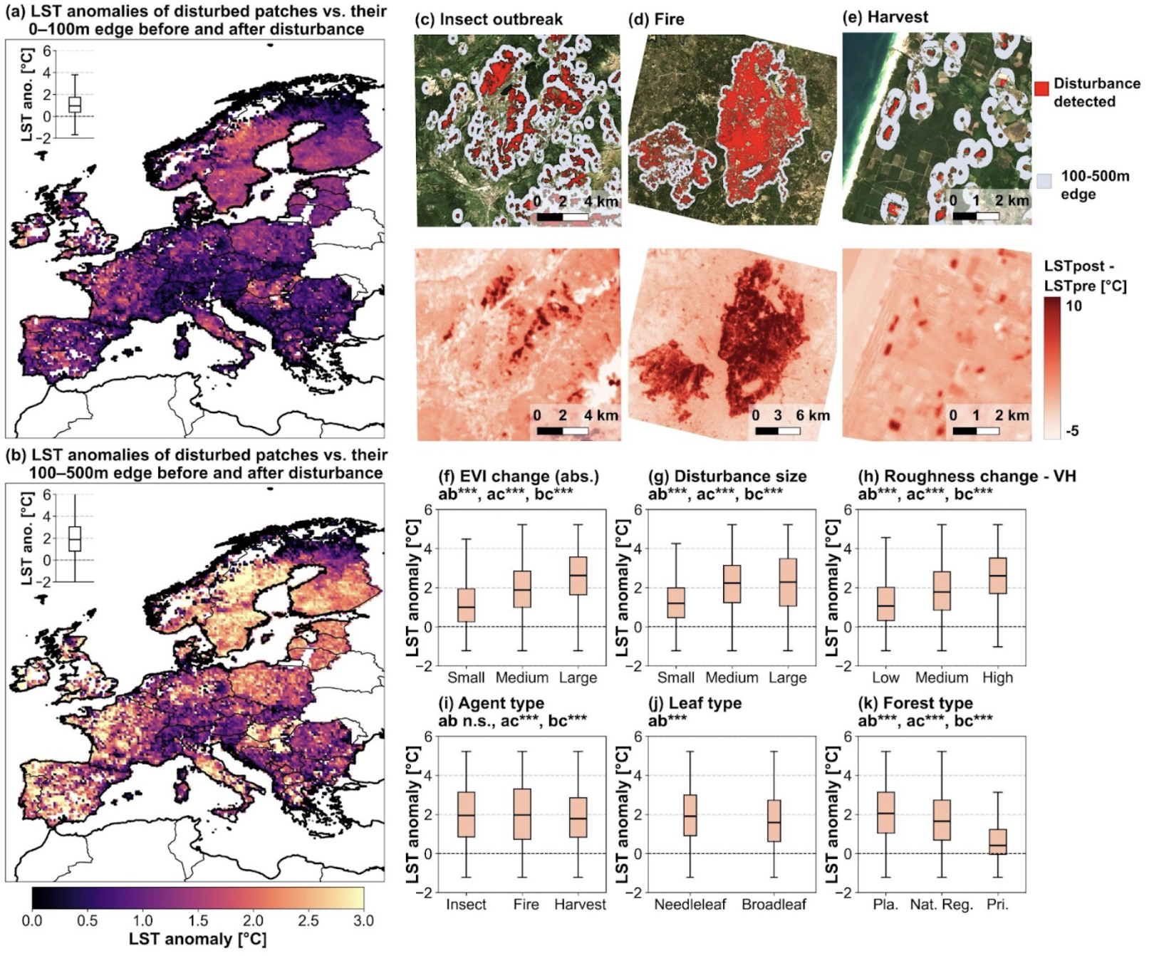
  1. Figure from Forest disturbances intensify land surface warming across Europe
    Preprint2026

    Forest disturbances intensify land surface warming across Europe

    Yang Su, Yidi Xu, Xianglin Zhang, David Makowski, Agnès Pelissier-Tanon, Saverio Francini, Tianqi Shi, Ke Yu, Siyu Li, Haotian Chen, Haoruo Li, Jinfeng Chang, Songchao Chen, Chaohui Yin, Nikola Besic, Martin Brandt, Alba Viana-Soto, Katja Kowalski, Cornelius Senf, Alexandre d’Aspremont, Philippe Ciais

    Disturbance Detection

    Forests are vital for the carbon sequestration, biodiversity conservation, and climate regulation, making the precise and continuous monitoring of forest structure attributes such as canopy height essential. Here we present a two decades long (2004–2024), 30 m resolution annual canopy height dataset for Italy, developed using a time-series deep learning framework that integrates Landsat optical imagery with LiDAR observations.

    Read full abstract ↗
    @misc{Su2028,
      title = {Forest disturbances intensify land surface warming across Europe},
      author = {Su, Yang and Xu, Yidi and Zhang, Xianglin and Makowski, David and Pelissier-Tanon, Agnès and Francini, Saverio and Shi, Tianqi and Yu, Ke and Li, Siyu and Chen, Haotian and Li, Haoruo and Chang, Jinfeng and Chen, Songchao and Yin, Chaohui and Besic, Nikola and Brandt, Martin and Viana-Soto, Alba and Kowalski, Katja and Senf, Cornelius and d’Aspremont, Alexandre and Ciais, Philippe},
      year = {2026},
      doi = {10.21203/rs.3.rs-8782712/v1}
    }
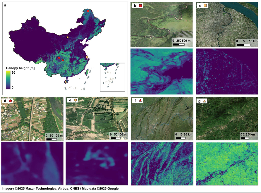
  2. Figure from Substantial contribution of trees outside forests to above-ground carbon across China
    Journal2026

    Substantial contribution of trees outside forests to above-ground carbon across China

    Yang Su, Tianqi Shi, Xianglin Zhang, Yidi Xu, Kai Cheng, Siyu Liu, Ge Han, Xin Ma, Songchao Chen, Xiaowei Tong, Wei Li, Wei Gong, Qinghua Guo, Martin Brandt, Shilong Piao, Alexandre d’Aspremont, Philippe Ciais

    Communications Earth & Environment

    Biomass Maps

    Accurately quantifying canopy height and above-ground carbon across diverse land-cover types is crucial for understanding carbon storage dynamics and guiding climate-mitigation strategies. Yet existing maps often overlook non-forest ecosystems. Here we present a deep learning framework based on a U-Net architecture that combines radar, optical, elevation and slope data to produce a 10 m canopy height map across China.x

    Read full abstract ↗
    @article{Su2026,
      title = {Substantial contribution of trees outside forests to above-ground carbon across China},
      author = {Su, Yang and Shi, Tianqi and Zhang, Xianglin and Xu, Yidi and Cheng, Kai and Liu, Siyu and Han, Ge and Ma, Xin and Chen, Songchao and Tong, Xiaowei and Li, Wei and Gong, Wei and Guo, Qinghua and Brandt, Martin and Piao, Shilong and d’Aspremont, Alexandre and Ciais, Philippe},
      year = {2026},
      journal = {Communications Earth & Environment},
      doi = {10.1038/s43247-025-03150-y}
    }
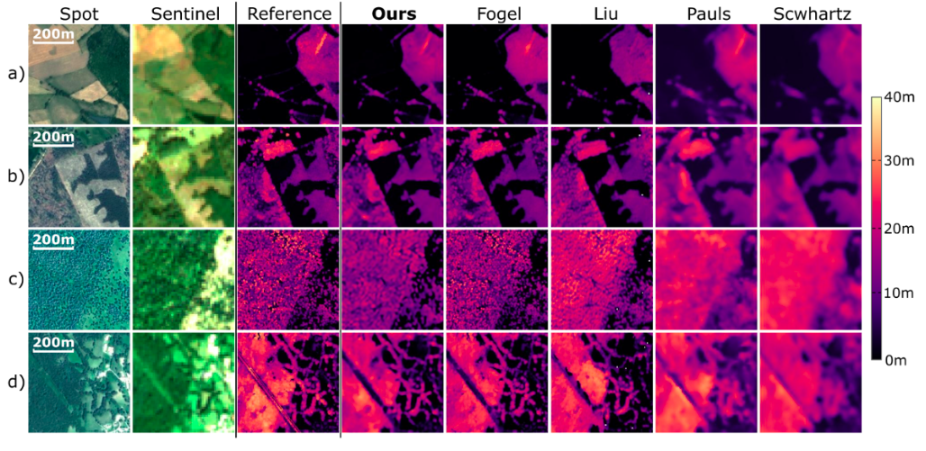
  3. Figure from SERA-H: Beyond Native Sentinel Spatial Limits for High-Resolution Canopy Height Mapping
    Preprint2026

    SERA-H: Beyond Native Sentinel Spatial Limits for High-Resolution Canopy Height Mapping

    Thomas Boudras, Martin Schwartz, Rasmus Fensholt, Martin Brandt, Ibrahim Fayad, Jean-Pierre Wigneron, Gabriel Belouze, Fajwel Fogel, Philippe Ciais

    Canopy Height MapsHigh Resolution

    High-resolution mapping of canopy height is essential for forest management and biodiversity monitoring. Although recent studies have led to the advent of deep learning methods using satellite imagery to predict height maps, these approaches often face a trade-off between data accessibility and spatial resolution. To overcome these limitations, we present SERA-H, an end-to-end model combining a super-resolution module (EDSR) and temporal attention encoding (UTAE).

    Read full abstract ↗
    @misc{boudras2026serahnativesentinelspatial,
      title = {SERA-H: Beyond Native Sentinel Spatial Limits for High-Resolution Canopy Height Mapping},
      author = {Boudras, Thomas and Schwartz, Martin and Fensholt, Rasmus and Brandt, Martin and Fayad, Ibrahim and Wigneron, Jean-Pierre and Belouze, Gabriel and Fogel, Fajwel and Ciais, Philippe},
      year = {2026},
      url = {https://arxiv.org/abs/2512.18128}
    }
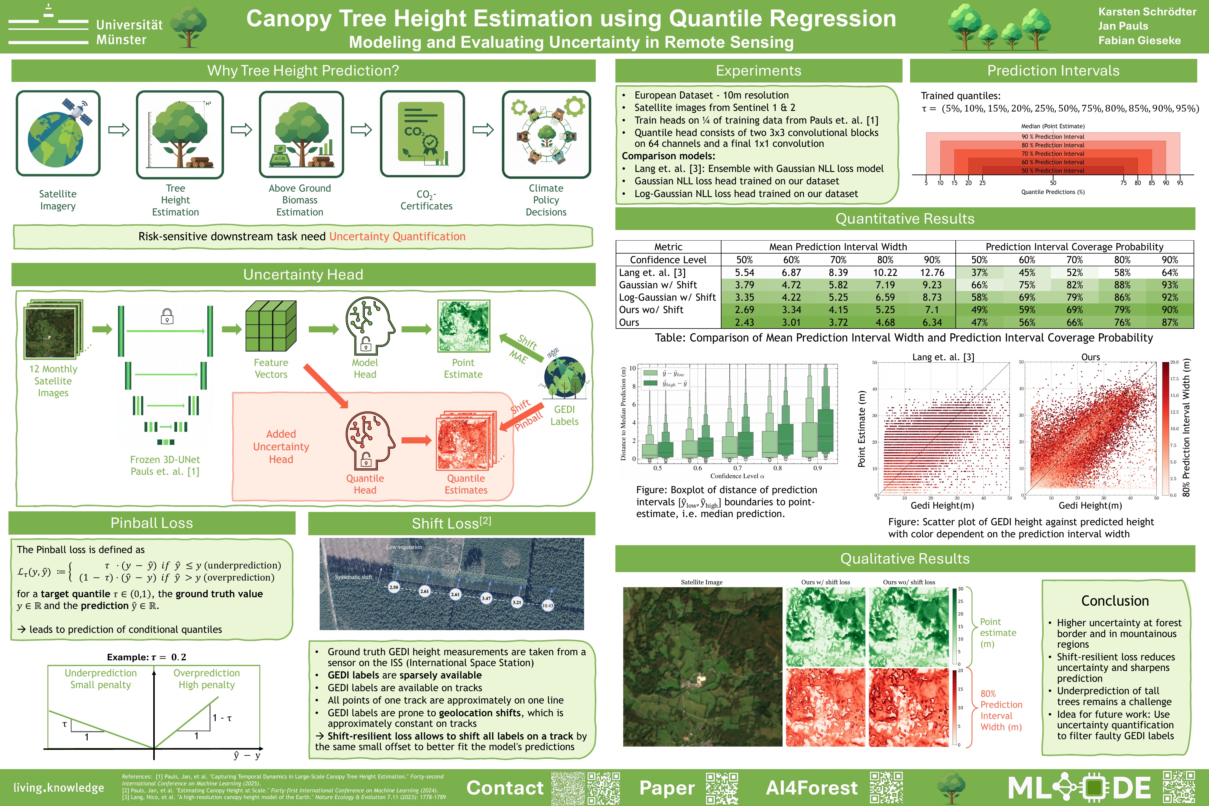
  4. Figure from Canopy Tree Height Estimation using Quantile Regression: Modeling and Evaluating Uncertainty in Remote Sensing
    AISTATS 262026

    Canopy Tree Height Estimation using Quantile Regression: Modeling and Evaluating Uncertainty in Remote Sensing

    Karsten Schrödter, Jan Pauls, Fabian Gieseke

    Proceedings of the 29th Annual Conference on Artificial Intelligence and Statistics (AISTATS)

    Uncertainty Quantification

    Accurate tree height estimation is vital for ecological monitoring and biomass assessment. We apply quantile regression to existing tree height estimation models based on satellite data to incorporate uncertainty quantification. Most current approaches for tree height estimation rely on point predictions, which limits their applicability in risk-sensitive scenarios. In this work, we show that, with minor modifications of a given prediction head, existing models can be adapted to provide statistically calibrated uncertainty estimates via quantile regression. Furthermore, we demonstrate how our results correlate with known challenges in remote sensing (e.g., terrain complexity, vegetation heterogeneity), indicating that the model is less confident in more challenging conditions.

    @inproceedings{SchroedterPG2026CanopyTree,
      title = {Canopy Tree Height Estimation using Quantile Regression: Modeling and Evaluating Uncertainty in Remote Sensing},
      author = {Schrödter, Karsten and Pauls, Jan and Gieseke, Fabian},
      year = {2026},
      booktitle = {Proceedings of the 29th Annual Conference on Artificial Intelligence and Statistics (AISTATS)},
      url = {https://arxiv.org/abs/2604.06988}
    }
  5. Figure from Trainable Bitwise Soft Quantization for Input Feature Compression
    CPAL 262026

    Trainable Bitwise Soft Quantization for Input Feature Compression

    Karsten Schrödter, Jan Stenkamp, Nina Herrmann, Fabian Gieseke

    Third Conference on Parsimony and Learning (CPAL)

    Model & Data Compression

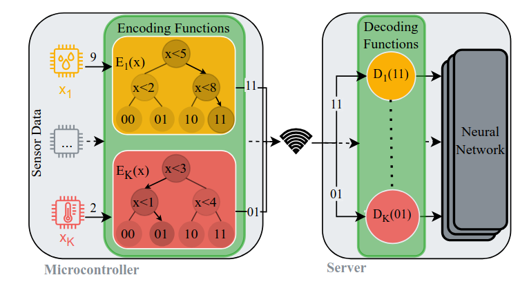
    Resource-constrained Internet of Things devices often rely on remote servers for machine learning inference, but data transmission is limited by bandwidth, latency, and energy constraints. We propose a task-specific, trainable feature quantization layer that compresses neural network inputs using a user-defined number of bits per feature. Our bitwise soft quantization approach uses sigmoid approximations of step functions to learn quantization thresholds and values, enabling simple on-device compression. Experiments show that it outperforms standard quantization methods and achieves 5×–16× compression compared to 32-bit inputs without significant performance loss.

    @inproceedings{schroedter2026bitwisequant,
      title = {Trainable Bitwise Soft Quantization for Input Feature Compression},
      author = {Schrödter, Karsten and Stenkamp, Jan and Herrmann, Nina and Gieseke, Fabian},
      year = {2026},
      booktitle = {Third Conference on Parsimony and Learning (CPAL)},
      url = {https://www.mldelab.de/publications/}
    }
  6. Figure from A fused canopy height map of Italy (2004–2024) from spaceborne and airborne LiDAR, and Landsat via deep learning and Bayesian averaging
    Preprint2025

    A fused canopy height map of Italy (2004–2024) from spaceborne and airborne LiDAR, and Landsat via deep learning and Bayesian averaging

    Yang Su, Nikola Besic, Xianglin Zhang, Yidi Xu, Saverio Francini, Giovanni D’Amico, Gherardo Chirici, Martin Schwartz, Ibrahim Fayad, Sarah Brood, Agnes Pellissier-tanon, Ke Yu, Haotian Chen, Songchao Chen, Alexandre d’Aspremont, Philippe Ciais

    Canopy Height Maps

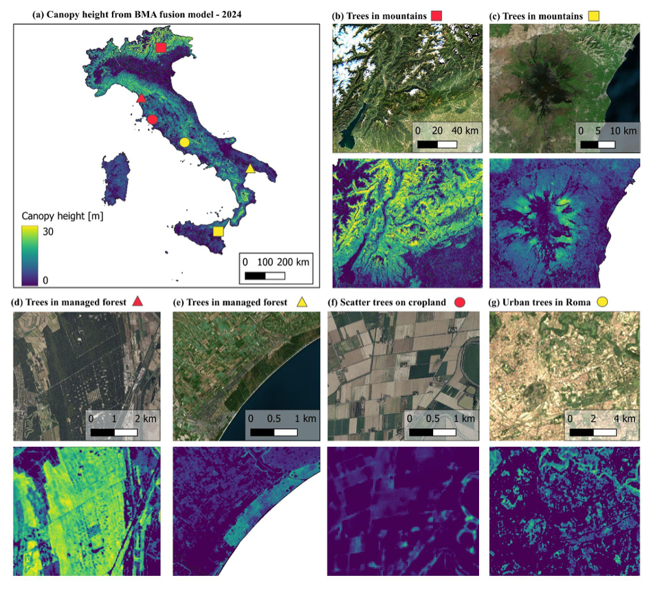
    Forests are vital for the carbon sequestration, biodiversity conservation, and climate regulation, making the precise and continuous monitoring of forest structure attributes such as canopy height essential. Here we present a two decades long (2004–2024), 30 m resolution annual canopy height dataset for Italy, developed using a time-series deep learning framework that integrates Landsat optical imagery with LiDAR observations.

    Read full abstract ↗
    @misc{Su2027,
      title = {A fused canopy height map of Italy (2004–2024) from spaceborne and airborne LiDAR, and Landsat via deep learning and Bayesian averaging},
      author = {Su, Yang and Besic, Nikola and Zhang, Xianglin and Xu, Yidi and Francini, Saverio and D’Amico, Giovanni and Chirici, Gherardo and Schwartz, Martin and Fayad, Ibrahim and Brood, Sarah and Pellissier-tanon, Agnes and Yu, Ke and Chen, Haotian and Chen, Songchao and d’Aspremont, Alexandre and Ciais, Philippe},
      year = {2025},
      doi = {10.5194/essd-2025-378}
    }
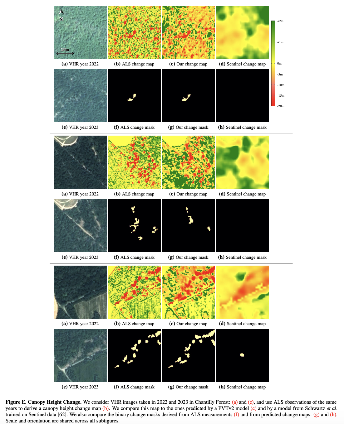
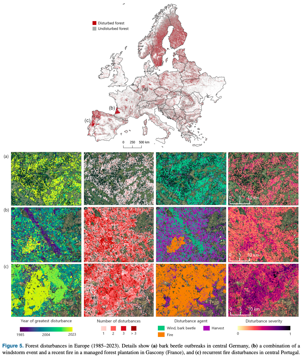
  7. Figure from Forest reburns are integral to southern Europe’s disturbance regimes
    Preprint2025

    Forest reburns are integral to southern Europe’s disturbance regimes

    Alba Viana-Soto, Cornelius Senf

    Disturbance Detection

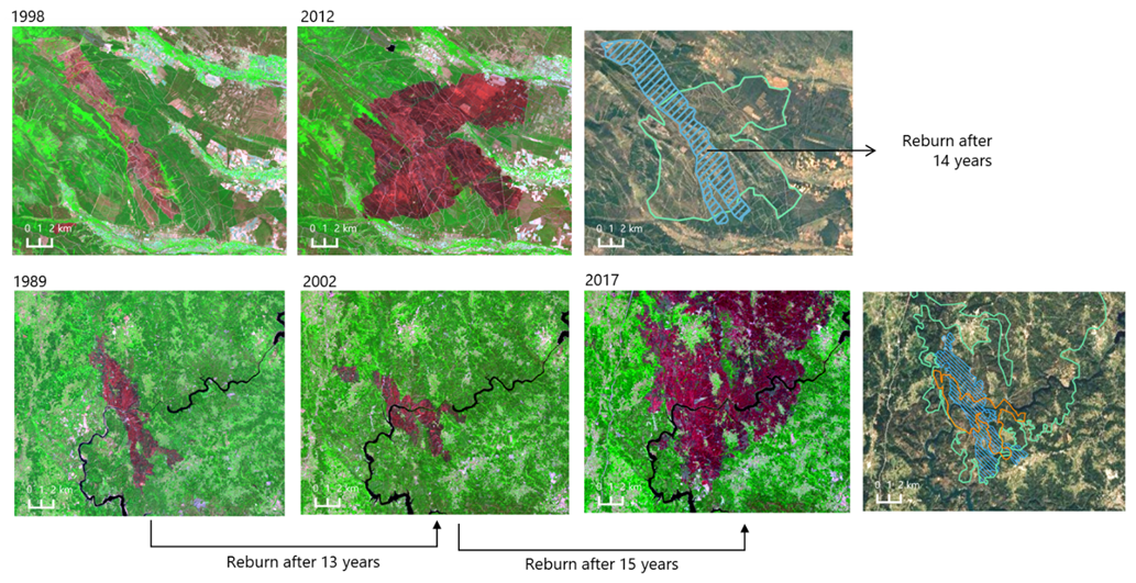
    Fires disturbances are integral to fire-prone landscapes of southern Europe. While evidence of changing fire frequency has been well documented in Europe, the dynamics of forest reburns - defined as previously burned areas that ignite again within intervals shorter than the historical range - remain largely unexplored. Here, we present the first large-scale characterization of reburns in southern Europe, using a novel remote sensing dataset on fire disturbances from 1985 to 2023.

    @misc{viana_soto_senf_2025_reburns,
      title = {Forest reburns are integral to southern Europe’s disturbance regimes},
      author = {Viana-Soto, Alba and Senf, Cornelius},
      year = {2025},
      doi = {10.21203/rs.3.rs-6937064/v1}
    }
  8. Figure from Canopy height and biomass distribution across the forests of Iberian Peninsula
    Journal2025

    Canopy height and biomass distribution across the forests of Iberian Peninsula

    Yang Su, Martin Schwartz, Ibrahim Fayad, Mariano García, Miguel A. Zavala, Julián Tijerín-Triviño, Julen Astigarraga, Verónica Cruz-Alonso, Siyu Liu, Xianglin Zhang, Songchao Chen, François Ritter, Nikola Besic, Alexandre d’Aspremont, Philippe Ciais

    Scientific Data

    Canopy Height MapsBiomass Maps

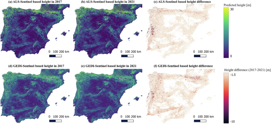
    Accurate mapping of vegetation canopy height and biomass distribution is essential for effective forest monitoring, climate change mitigation, and sustainable forestry. Here we present high-resolution remote sensing-based canopy height (10 m resolution) and above ground biomass (AGB, 50 m resolution) maps for the forests of the Iberian Peninsula from 2017 to 2021, using a deep learning framework that integrates Sentinel-1, Sentinel-2, and LiDAR data. Two UNET models were developed...

    Read full abstract ↗
    @article{Su2025,
      title = {Canopy height and biomass distribution across the forests of Iberian Peninsula},
      author = {Su, Yang and Schwartz, Martin and Fayad, Ibrahim and García, Mariano and Zavala, Miguel A. and Tijerín-Triviño, Julián and Astigarraga, Julen and Cruz-Alonso, Verónica and Liu, Siyu and Zhang, Xianglin and Chen, Songchao and Ritter, François and Besic, Nikola and d’Aspremont, Alexandre and Ciais, Philippe},
      year = {2025},
      journal = {Scientific Data},
      doi = {10.1038/s41597-025-05021-9}
    }
  9. Figure from Remote-sensing-based forest canopy height mapping: some models are useful, but might they provide us with even more insights when combined?
    Journal2025

    Remote-sensing-based forest canopy height mapping: some models are useful, but might they provide us with even more insights when combined?

    N. Besic, N. Picard, C. Vega, J.-D. Bontemps, L. Hertzog, J.-P. Renaud, F. Fogel, M. Schwartz, A. Pellissier-Tanon, G. Destouet, F. Mortier, M. Planells-Rodriguez, P. Ciais

    Geoscientific Model Development

    Canopy Height Maps

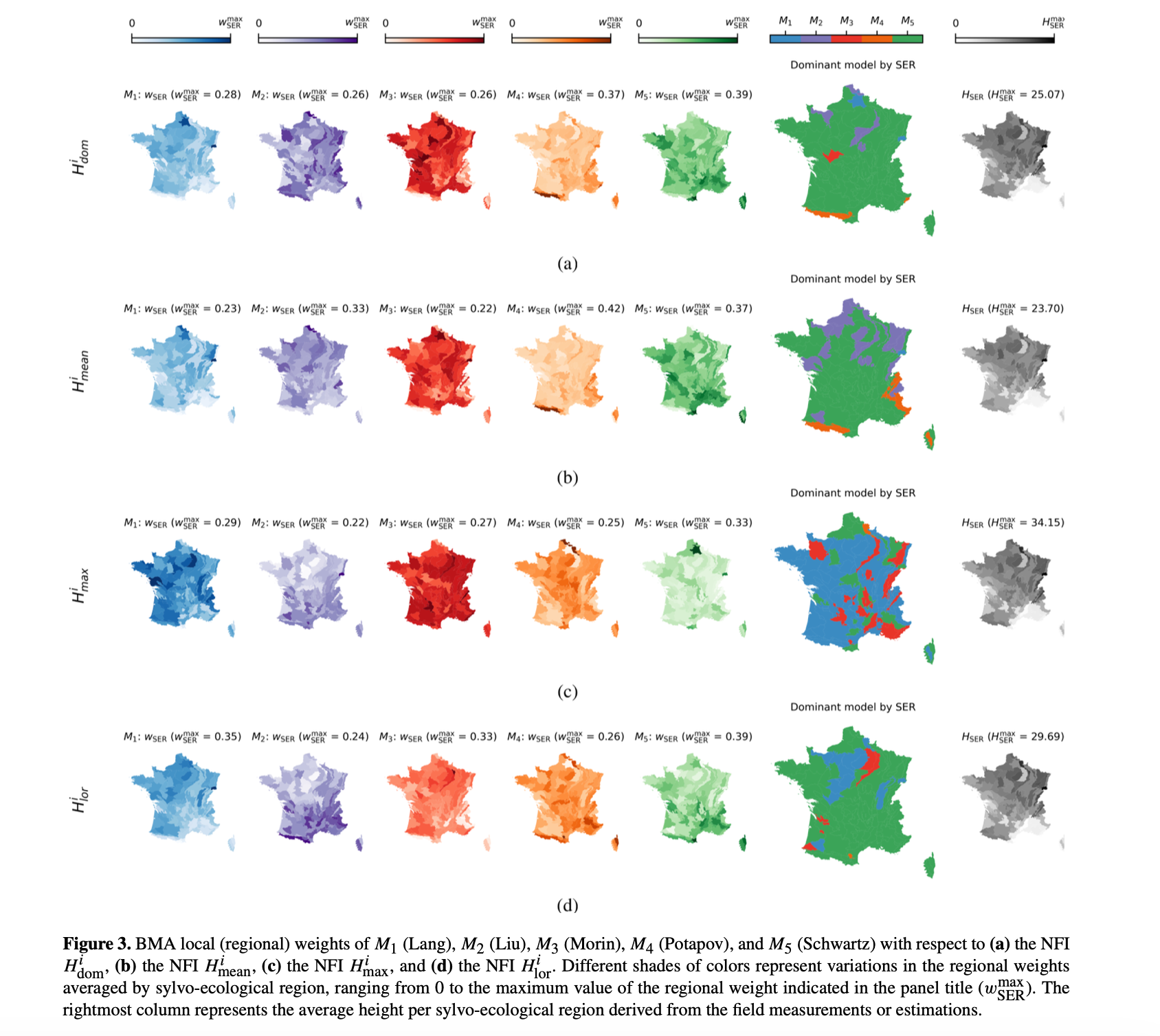
    The development of high-resolution mapping models for forest attributes based on remote sensing data combined with machine or deep learning techniques has become a prominent topic in the field of forest observation and monitoring. This has resulted in the availability of multiple, sometimes conflicting, sources of information, but, at face value, it also makes it possible to learn about forest attribute uncertainty through the joint interpretation of multiple models. This article seeks to endorse the latter by ...

    Read full abstract ↗
    @article{gmd-18-337-2025,
      title = {Remote-sensing-based forest canopy height mapping: some models are useful, but might they provide us with even more insights when combined?},
      author = {Besic, N. and Picard, N. and Vega, C. and Bontemps, J.-D. and Hertzog, L. and Renaud, J.-P. and Fogel, F. and Schwartz, M. and Pellissier-Tanon, A. and Destouet, G. and Mortier, F. and Planells-Rodriguez, M. and Ciais, P.},
      year = {2025},
      journal = {Geoscientific Model Development},
      doi = {10.5194/gmd-18-337-2025},
      url = {https://gmd.copernicus.org/articles/18/337/2025/}
    }
  10. Figure from Capturing Temporal Dynamics in Large-Scale Canopy Tree Height Estimation
    ICML 252025

    Capturing Temporal Dynamics in Large-Scale Canopy Tree Height Estimation

    Jan Pauls, Max Zimmer, Berkant Turan, Sassan Saatchi, Philippe Ciais, Sebastian Pokutta, Fabian Gieseke

    International Conference on Machine Learning (ICML)

    Canopy Height MapsDisturbance Detection

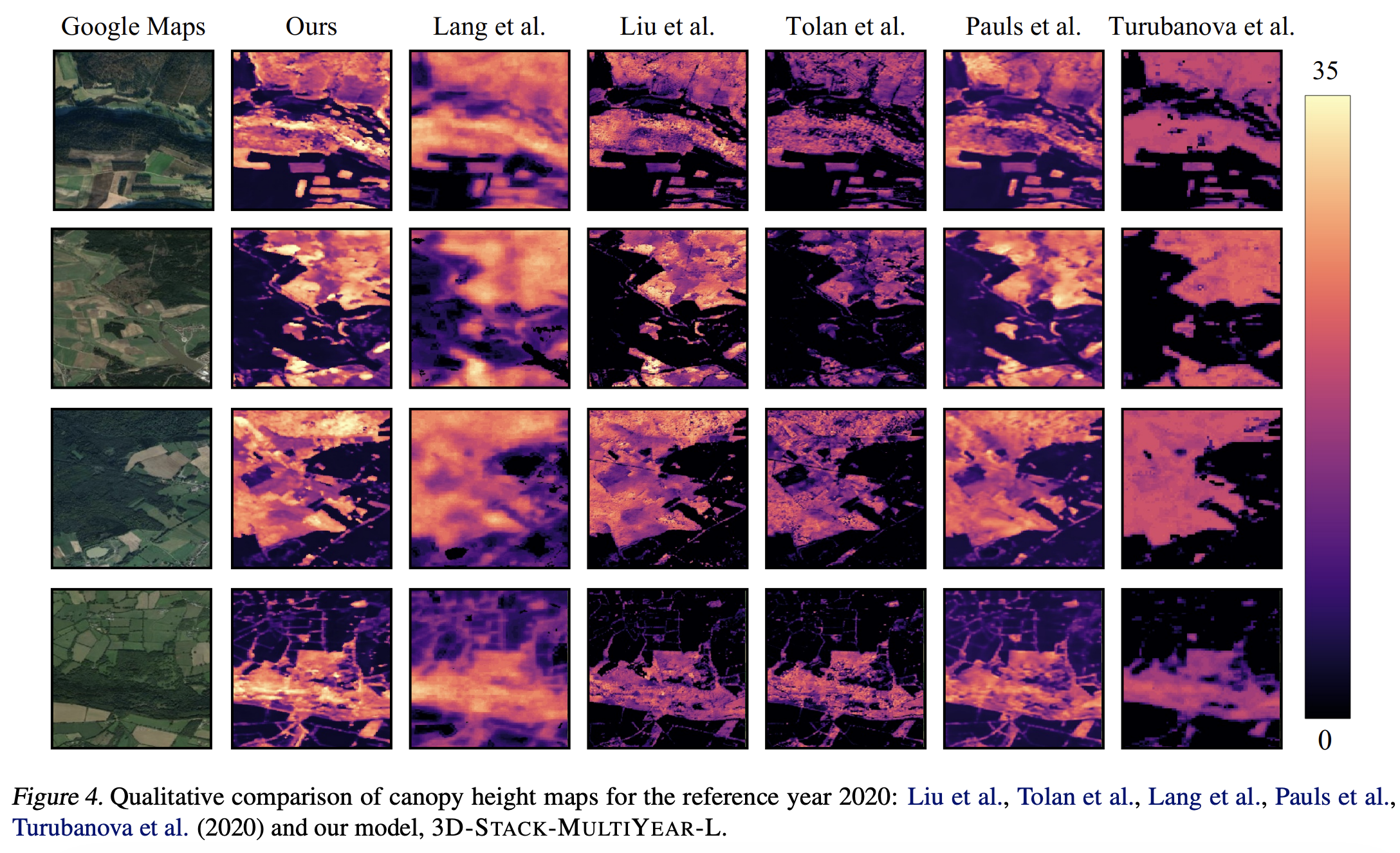
    With the rise in global greenhouse gas emissions, accurate large-scale tree canopy height maps are essential for understanding forest structure, estimating above-ground biomass, and monitoring ecological disruptions. To this end, we present a novel approach to generate large-scale, high-resolution canopy height maps over time.

    Read full abstract ↗
    @inproceedings{pauls2025capturing,
      title = {Capturing Temporal Dynamics in Large-Scale Canopy Tree Height Estimation},
      author = {Pauls, Jan and Zimmer, Max and Turan, Berkant and Saatchi, Sassan and Ciais, Philippe and Pokutta, Sebastian and Gieseke, Fabian},
      year = {2025},
      booktitle = {International Conference on Machine Learning (ICML)},
      url = {https://arxiv.org/abs/2501.19328}
    }
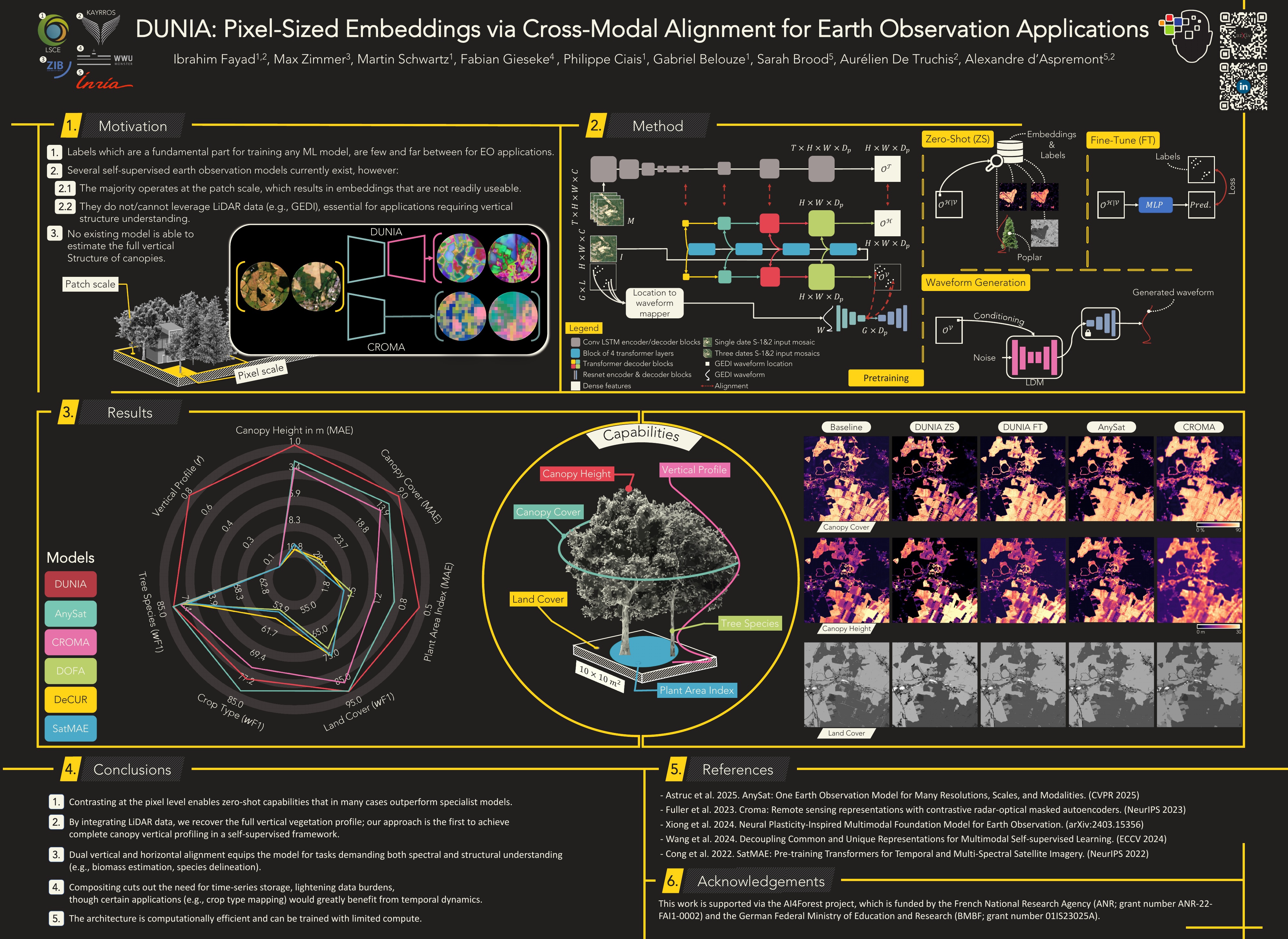
  11. Figure from DUNIA: Pixel-Sized Embeddings via Cross-Modal Alignment for Earth Observation Applications
    ICML 252025

    DUNIA: Pixel-Sized Embeddings via Cross-Modal Alignment for Earth Observation Applications

    Ibrahim Fayad, Max Zimmer, Martin Schwartz, Philippe Ciais, Fabian Gieseke, Gabriel Belouze, Sarah Brood, Aurelien De Truchis, Alexandre d’Aspremont

    International Conference on Machine Learning (ICML)

    Foundation Models

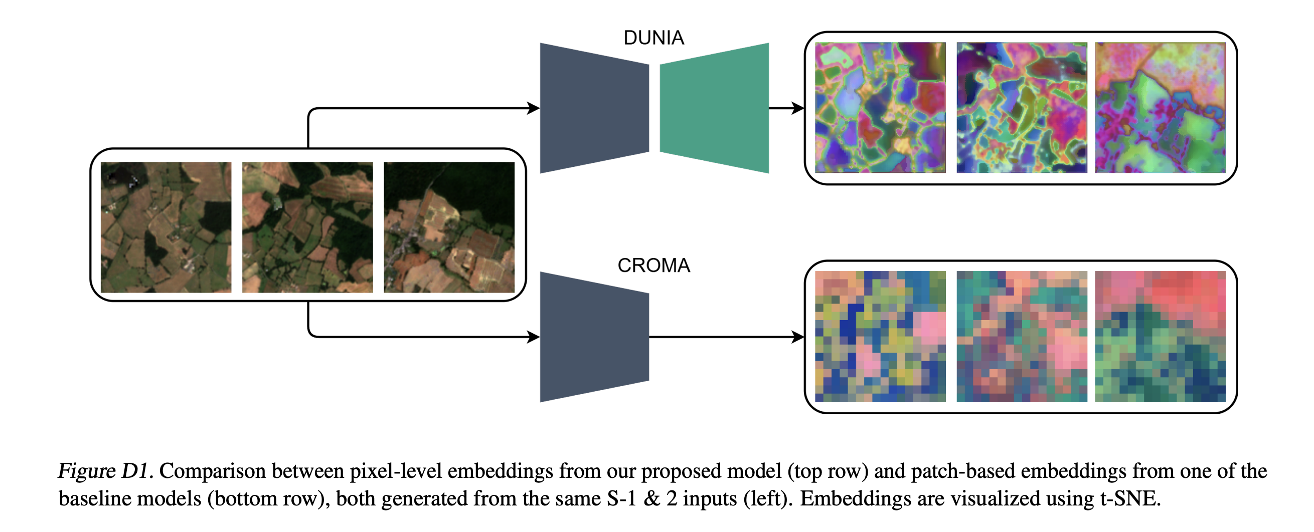
    Significant efforts have been directed towards adapting self-supervised multimodal learning for Earth observation applications. However, most current methods produce coarse patch-sized embeddings, limiting their effectiveness and integration with other modalities like LiDAR. To close this gap, we present DUNIA, an approach to learn pixel-sized embeddings through

    Read full abstract ↗
    @inproceedings{fayad2025dunia,
      title = {DUNIA: Pixel-Sized Embeddings via Cross-Modal Alignment for Earth Observation Applications},
      author = {Fayad, Ibrahim and Zimmer, Max and Schwartz, Martin and Ciais, Philippe and Gieseke, Fabian and Belouze, Gabriel and Brood, Sarah and De Truchis, Aurelien and d’Aspremont, Alexandre},
      year = {2025},
      booktitle = {International Conference on Machine Learning (ICML)},
      url = {https://arxiv.org/abs/2502.17066}
    }
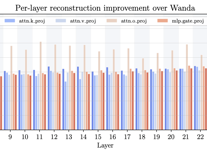
  12. Figure from SparseSwaps: Tractable LLM Pruning Mask Refinement at Scale
    Preprint2025

    SparseSwaps: Tractable LLM Pruning Mask Refinement at Scale

    Max Zimmer, Christophe Roux, Moritz Wagner, Deborah Hendrych, Sebastian Pokutta

    arXiv preprint arXiv:2512.10922

    Sparse Neural Nets

    The resource requirements of neural networks can be significantly reduced through pruning - the removal of seemingly less important parameters. However, for LLMs, full retraining to recover pruning-induced performance degradation is often prohibitive and classical approaches such as magnitude pruning are suboptimal on Transformers.

    Read full abstract ↗
    @article{zimmer2025sparseswaps,
      title = {SparseSwaps: Tractable LLM Pruning Mask Refinement at Scale},
      author = {Zimmer, Max and Roux, Christophe and Wagner, Moritz and Hendrych, Deborah and Pokutta, Sebastian},
      year = {2025},
      journal = {arXiv preprint arXiv:2512.10922},
      doi = {10.48550/arXiv.2512.10922}
    }
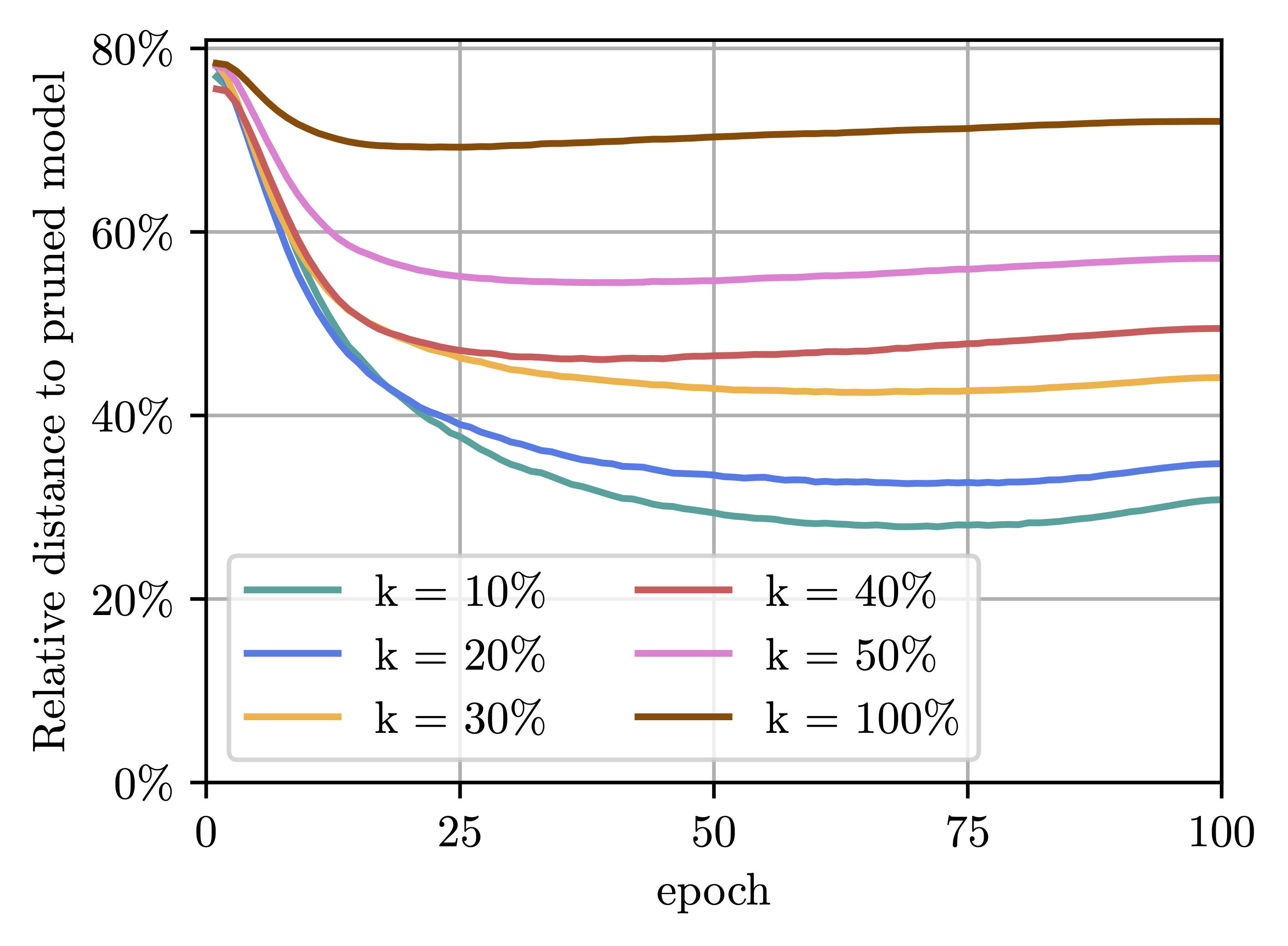
  13. Figure from Compression-aware Training of Neural Networks using Frank-Wolfe
    Book chapter2025

    Compression-aware Training of Neural Networks using Frank-Wolfe

    Max Zimmer, Christoph Spiegel, Sebastian Pokutta

    Mathematical Optimization for Machine Learning

    Sparse Neural Nets

    Many existing neural network pruning approaches rely on either retraining or inducing a strong bias in order to converge to a sparse solution throughout training. A third paradigm, compression-aware training, aims to obtain state-of-the-art dense models that are robust to a wide range of compression ratios using a single dense training run while also avoiding retraining.

    Read full abstract ↗
    @inbook{ZimmerSpiegelPokutta+2025+137+168,
      title = {Compression-aware Training of Neural Networks using Frank-Wolfe},
      author = {Zimmer, Max and Spiegel, Christoph and Pokutta, Sebastian},
      year = {2025},
      booktitle = {Mathematical Optimization for Machine Learning},
      doi = {10.1515/9783111376776-010},
      url = {https://doi.org/10.1515/9783111376776-010}
    }
  14. Figure from High-resolution canopy height map in the Landes forest (France) based on GEDI, Sentinel-1, and Sentinel-2 data with a deep learning approach
    Journal2024

    High-resolution canopy height map in the Landes forest (France) based on GEDI, Sentinel-1, and Sentinel-2 data with a deep learning approach

    Martin Schwartz, Philippe Ciais, Catherine Ottlé, Aurelien De Truchis, Cedric Vega, Ibrahim Fayad, Martin Brandt, Rasmus Fensholt, Nicolas Baghdadi, François Morneau, David Morin, Dominique Guyon, Sylvia Dayau, Jean-Pierre Wigneron

    International Journal of Applied Earth Observation and Geoinformation

    Canopy Height MapsHigh Resolution

    In intensively managed forests in Europe, where forests are divided into stands of small size and may show heterogeneity within stands, a high spatial resolution (10–––20 m) is needed to capture the differences in canopy height. In this work, we developed a deep learning model based on multi-sensor remote sensing measurements to create a high-resolution canopy height map over the “Landes de Gascogne” forest in France, a large maritime pine plantation of 13,000 km2 with flat terrain and intensive management.

    Read full abstract ↗
    @article{schwartz_high-resolution_2024,
      title = {High-resolution canopy height map in the Landes forest (France) based on GEDI, Sentinel-1, and Sentinel-2 data with a deep learning approach},
      author = {Schwartz, Martin and Ciais, Philippe and Ottlé, Catherine and De Truchis, Aurelien and Vega, Cedric and Fayad, Ibrahim and Brandt, Martin and Fensholt, Rasmus and Baghdadi, Nicolas and Morneau, François and Morin, David and Guyon, Dominique and Dayau, Sylvia and Wigneron, Jean-Pierre},
      year = {2024},
      journal = {International Journal of Applied Earth Observation and Geoinformation},
      doi = {10.1016/j.jag.2024.103711},
      url = {https://www.sciencedirect.com/science/article/pii/S1569843224000657}
    }
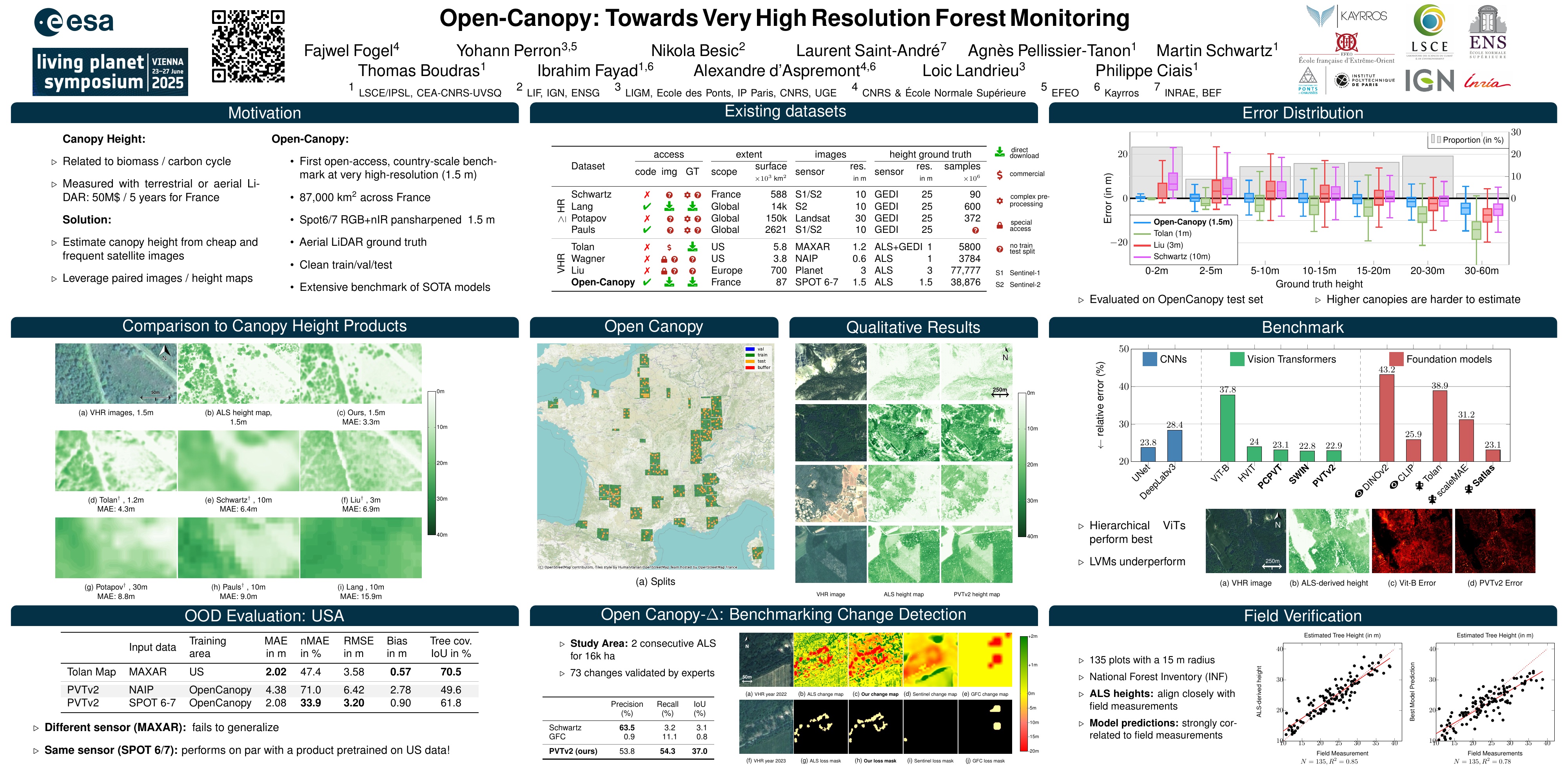
  15. Figure from Open-Canopy: Towards Very High Resolution Forest Monitoring
    Preprint2024

    Open-Canopy: Towards Very High Resolution Forest Monitoring

    François Fogel, Martin Schwartz, Philippe Ciais, Aurélien De Truchis, Cedric Vega, Ibrahim Fayad, Martin Brandt

    arXiv preprint arXiv:2407.09392

    High Resolution

    We introduce Open-Canopy, a high-resolution approach to forest monitoring.

    Read full abstract ↗
    @article{fogel2024opencanopy,
      title = {Open-Canopy: Towards Very High Resolution Forest Monitoring},
      author = {Fogel, François and Schwartz, Martin and Ciais, Philippe and De Truchis, Aurélien and Vega, Cedric and Fayad, Ibrahim and Brandt, Martin},
      year = {2024},
      journal = {arXiv preprint arXiv:2407.09392},
      url = {https://arxiv.org/abs/2407.09392}
    }
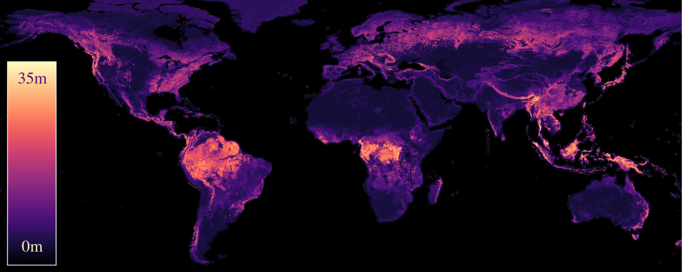
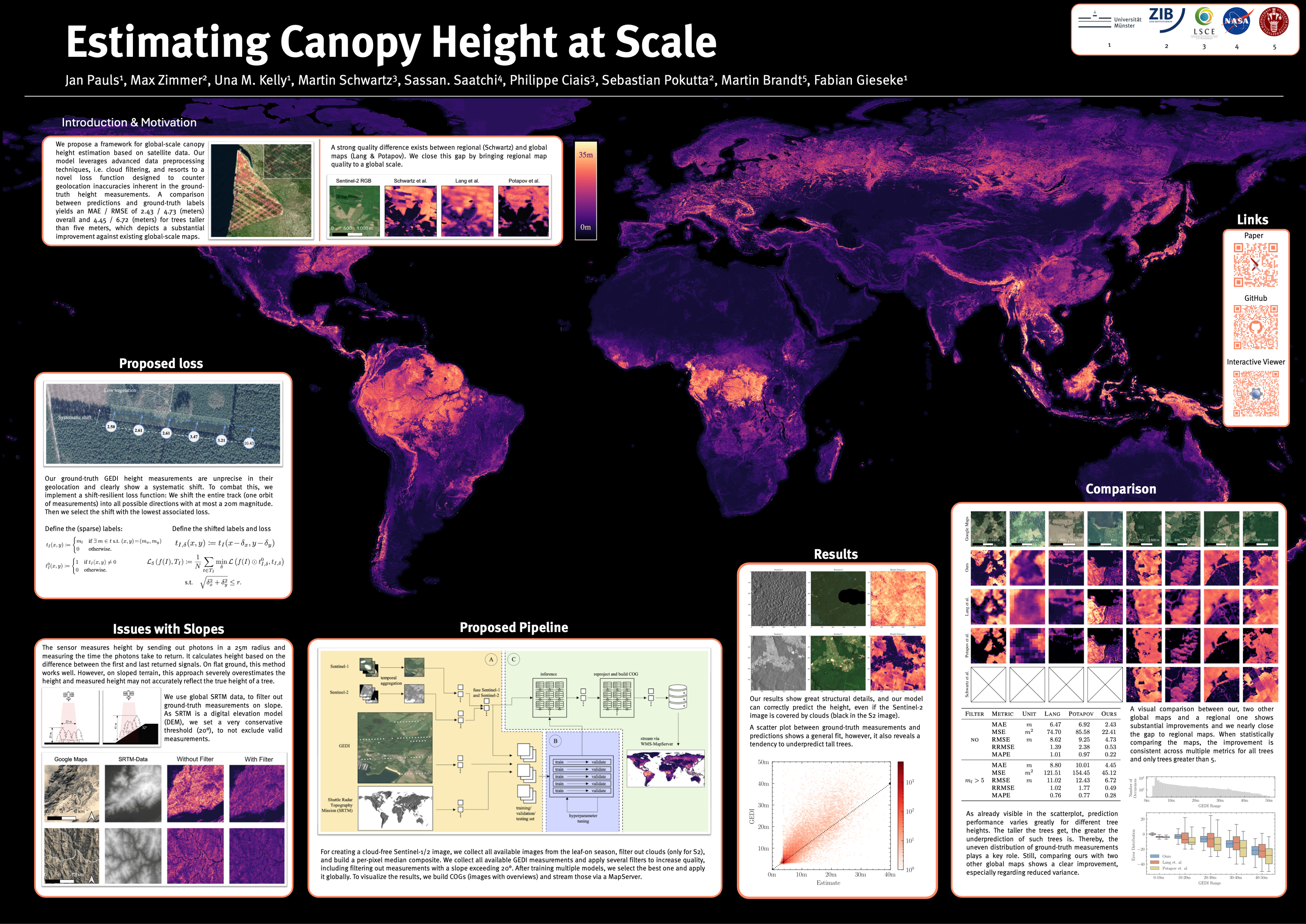
  16. Figure from Estimating canopy height at scale
    ICML 242024

    Estimating canopy height at scale

    Jan Pauls, Max Zimmer, Una M Kelly, Martin Schwartz, Sassan Saatchi, Philippe Ciais, Sebastian Pokutta, Martin Brandt, Fabian Gieseke

    International Conference on Machine Learning (ICML)

    Canopy Height Maps

    We propose a framework for global-scale canopy height estimation based on satellite data. Our model leverages advanced data preprocessing techniques, resorts to a novel loss function designed to counter geolocation inaccuracies inherent in the ground-truth height measurements, and employs data from the Shuttle Radar Topography Mission to effectively filter out erroneous labels in mountainous regions, enhancing the reliability of our predictions in those areas.

    Read full abstract ↗
    @inproceedings{pauls2024estimating,
      title = {Estimating canopy height at scale},
      author = {Pauls, Jan and Zimmer, Max and Kelly, Una M and Schwartz, Martin and Saatchi, Sassan and Ciais, Philippe and Pokutta, Sebastian and Brandt, Martin and Gieseke, Fabian},
      year = {2024},
      booktitle = {International Conference on Machine Learning (ICML)},
      url = {https://arxiv.org/abs/2406.01076}
    }
  17. Figure from The European Forest Disturbance Atlas: a forest disturbance monitoring system using the Landsat archive
    Journal2024

    The European Forest Disturbance Atlas: a forest disturbance monitoring system using the Landsat archive

    Alba Viana-Soto, Cornelius Senf, Julian Sebald, Rupert Seidl

    Earth System Science Data Discussions

    Disturbance Detection

    Forests in Europe are undergoing complex changes that require a comprehensive monitoring of disturbance occurrence. Here, we present the European Forest Disturbance Atlas (EFDA), a Landsat-based approach for mapping annual forest disturbances across continental Europe from 1985 onwards.

    Read full abstract ↗
    @article{VianaSotoandSenf2024,
      title = {The European Forest Disturbance Atlas: a forest disturbance monitoring system using the Landsat archive},
      author = {Viana-Soto, Alba and Senf, Cornelius and Sebald, Julian and Seidl, Rupert},
      year = {2024},
      journal = {Earth System Science Data Discussions},
      url = {https://essd.copernicus.org/preprints/essd-2024-123/}
    }
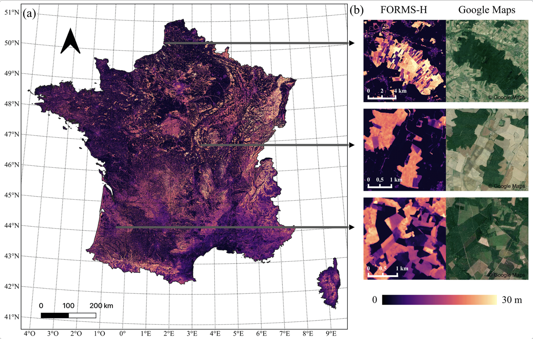
  18. Figure from FORMS: Forest Multiple Source height, wood volume, and biomass maps in France at 10 to 30 m resolution based on Sentinel-1, Sentinel-2, and Global Ecosystem Dynamics Investigation (GEDI) data with a deep learning approach
    Journal2023

    FORMS: Forest Multiple Source height, wood volume, and biomass maps in France at 10 to 30 m resolution based on Sentinel-1, Sentinel-2, and Global Ecosystem Dynamics Investigation (GEDI) data with a deep learning approach

    Martin Schwartz, Philippe Ciais, Aurélien De Truchis, Jérôme Chave, Catherine Ottlé, Cedric Vega, Jean-Pierre Wigneron, Manuel Nicolas, Sami Jouaber, Siyu Liu, Martin Brandt, Ibrahim Fayad

    Earth System Science Data

    Canopy Height MapsBiomass Maps

    The contribution of forests to carbon storage and biodiversity conservation highlights the need for accurate forest height and biomass mapping and monitoring. In France, forests are managed mainly by private owners and divided into small stands, requiring 10 to 50m spatial resolution data to be correctly separated. Further, 35% of the French forest territory is covered by mountains and Mediterranean forests which are managed very extensively.

    Read full abstract ↗
    @article{schwartz_forms_2023,
      title = {FORMS: Forest Multiple Source height, wood volume, and biomass maps in France at 10 to 30 m resolution based on Sentinel-1, Sentinel-2, and Global Ecosystem Dynamics Investigation (GEDI) data with a deep learning approach},
      author = {Schwartz, Martin and Ciais, Philippe and De Truchis, Aurélien and Chave, Jérôme and Ottlé, Catherine and Vega, Cedric and Wigneron, Jean-Pierre and Nicolas, Manuel and Jouaber, Sami and Liu, Siyu and Brandt, Martin and Fayad, Ibrahim},
      year = {2023},
      journal = {Earth System Science Data},
      doi = {10.5194/essd-15-4927-2023},
      url = {https://essd.copernicus.org/articles/15/4927/2023/}
    }
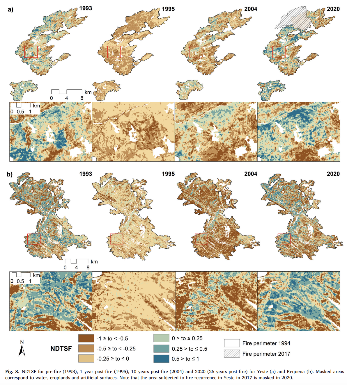
  19. Figure from Quantifying post-fire shifts in woody-vegetation cover composition in Mediterranean pine forests using Landsat time series and regression-based unmixing
    Journal2022

    Quantifying post-fire shifts in woody-vegetation cover composition in Mediterranean pine forests using Landsat time series and regression-based unmixing

    Alba Viana-Soto, Akpona Okujeni, Dirk Pflugmacher, Mariano García, Inmaculada Aguado, Patrick Hostert

    Remote Sensing of Environment

    Disturbance Detection

    In this study, we demonstrate how fractional time series of different woody-vegetation types support the analysis of post-fire vegetation recovery in relation to the pre-fire situation for two burned areas in Mediterranean pine forests in Spain.

    Read full abstract ↗
    @article{VIANASOTO2022113239,
      title = {Quantifying post-fire shifts in woody-vegetation cover composition in Mediterranean pine forests using Landsat time series and regression-based unmixing},
      author = {Viana-Soto, Alba and Okujeni, Akpona and Pflugmacher, Dirk and García, Mariano and Aguado, Inmaculada and Hostert, Patrick},
      year = {2022},
      journal = {Remote Sensing of Environment},
      doi = {10.1016/j.rse.2022.113239},
      url = {https://www.sciencedirect.com/science/article/pii/S0034425722003455}
    }

AI4Forest

AI4Forest is a research project that combines artificial intelligence and forest science to better understand and manage forest ecosystems.

Research Areas
Contact Principal Investigators
Prof. Dr. Philippe Ciais
Laboratoire des Sciences du Climat et de l'Environnement
Université Paris Saclay
Tél. : 01.69.08.95.06
Email
Prof. Dr. Alexandre d'Aspremont
CNRS - ENS
45 rue d'Ulm
Paris, France
48 rue Barrault
75013 Paris
Email
Prof. Dr. Fabian Gieseke
University of Münster
Leonardo Campus 3
48149 Münster
Telefon: +49 251 83-38151
Email
Prof. Dr. Sebastian Pokutta
Einrichtung FG Mathematische Optimierung
Takustraße 7
14195 Berlin
Tel.: +49 30 84185-209
Email
Prof. Dr. Cornelius Senf
School of Life Sciences
Hans-Carl-v.-Carlowitz-Platz 2
85354 Freising
Tel.: +49.8161.71.4371
Email